Graphite CreekAmerica’s highest grade and largest known, large flake graphite deposit Location The Graphite Creek Property comprises 165 mineral claims totaling 7,317 hectares, on the Seward Peninsula of Alaska, about 59 kilometres (“km”) north of the city of Nome. The Property is 20 km from a seasonal road, 4 km from tidewater at Windy Cove (Imuruk Basin) and 3 km from an airstrip to the southeast. Mineralization The Graphite Creek Deposit is characterized by coarse, crystalline (large-flake), graphite within graphite-bearing schist. Graphite mineralization is exposed at surface along the Kigluaik Mountain Range front. The large flake graphite occurs as disseminations and high grade segregations and lenses in distinct sillimanite-garnet-quartz-biotite schist and/or quartz-biotite schist. The host schist is continuous over 18 KM of strike length, based on mapping, sampling and airborne geophysics. Two studies from TRU Group Inc. were commissioned by the Company in mid-2014 and early 2015 to study the development options for the property and test work conducted to determine the characteristics of the Deposit’s graphite. The second report identified unique characteristics of the Graphite Creek graphite. Detailed analyses of samples from six, high-grade drill holes across the length of the deposit were conducted. The characterization techniques used were:
These distinguishing features can be described as Spheroidal, Thin, Aggregate and eXpanded, or STAX. Additional research and development will be required to assess the impact of these findings, but the Company believes that STAX has the potential to have a positive impact on the Preliminary Economic Assessment (“PEA”). Important conclusions resulting from this characterization testwork include findings of:
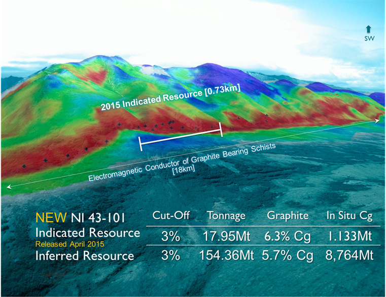
NI 43-101 Resource Estimate On March 17, 2015, the Company provided an updated resource estimate of 17.95 million tonnes (“Mt”) indicated grading 6.3% graphitic carbon (“Cg”) and 154.36 Mt inferred with 5.7% Cg, using a 3% cut-off grade. These results moved a portion of the previously released resource estimate (Media release January 20, 2014) from inferred to indicated resource status.
1: This resource estimate recommends using a 3.0 % Cg cut-off grade for the base case to be consistent with resource recovery of 80 to 95% Graphite concentrate with average selling price of USD$1,400/tonne.
History The Graphite Creek Property is historically characterized by a series of large-flake, high-grade graphite deposits or lenses that crop out in incised creek valleys on the northern, lowermost slopes of the Kigluaik Mountains. The graphite showings were first discovered after the 1898 Cape Nome gold rush, and have been reported under several names including the Uncle Sam, Tweet and Kigluaik graphite deposits. The deposits were intermittently mined from 1907 to 1920 with some 580 tonnes of hand-sorted graphite mined from talus and adits (small <10 m excavations into exposed outcrop) that penetrated high-grade graphitic zones. Prior to Graphite One’s interest, the deposits were last explored during the mid-1990s when mapping, sampling and mineralogical (x-ray diffraction) work was conducted. The graphite showings were never drill tested prior to Graphite One’s 2012 exploration program. Geology The graphite deposits consist mainly of segregations (lenses and streaks) of semi-massive to massive graphite and graphite disseminations that are hosted in schistose rocks within the lower granulite facies portion of the Kigluaik Group. Based on surface exposures and workings, the deposits are known to strike in a northeasterly direction adjacent to the high angle, strike-slip Kigluaik Fault. Graphite zones within the schistose rocks occur as: 1) massive resistant graphite segregations in sillimanite-garnet-biotite quartz schist; 2) flaky graphitic sillimanite-garnet-biotite-quartz schist consisting of 15-55% large graphite flakes; and 3) graphitic biotite-quartz schist containing 1-10% disseminated graphite. |
||||||||||||||||||||||||||||||||||||||||
6/13/2017 Last 0.07 Volume 217133
Day High 0.07 Day Low 0.06